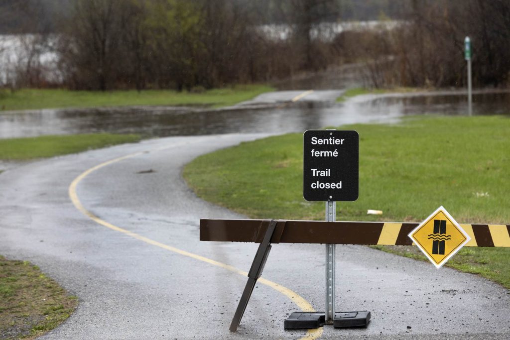
Water levels in Ottawa, Gatineau expected to rise in coming days
Posted May 2, 2023 04:53:46 PM.
Last Updated May 3, 2023 04:48:21 PM.
The Ottawa River levels are expected to rise in the coming days, but the City of Ottawa says the impact on the city itself remains minimal.
Ottawa Flood Operations
The City of Ottawa predicts levels will increase by 25 to 35 centimetres, but it’s expected to remain below historical flood levels. The Ottawa River Regulating Committee estimates water levels are expected to remain below 2019 historic flood levels along the main stem of the Ottawa River.
About 130 private properties have implemented flood mitigation measures such as sandbags and the city says the majority of them are in West Carleton. For those in flood-prone areas, the city says resources such as sandbags, are available to residents at multiple locations.
The Ottawa River Regulation Planning Board (ORRB), says the rapid rise in water levels is expected to stabilize and will be followed by a gradual rise before reaching a peak towards the end of the week.
Lower Ottawa River Flood Warnings
- On Tuesday, May 2, The Rideau Valley Conservation Authority (RVCA) issued a flood warning for areas along the Lower Ottawa River from Arnprior to Hawkesbury.
- The RVCA says water levels are expected to rise again within the Ottawa River Basin because of significant rainfall. The runoff will bring additional water volumes to the Ottawa River at a time when levels are already near major flood thresholds.
- Based on Ottawa River Regulating Committee forecasts, flood-prone areas along the main stem of the Ottawa River from Arnprior to Hawkesbury are at risk.
- As of Wednesday, May 3, levels in Mattawa and Pembroke are now expected to slightly exceed the major flood threshold. Levels are above the major flood threshold in Lake Coulonge since April 19 and are expected to exceed that threshold in Chats Lake and Lake Deschenes.
- Water levels are currently expected to remain 45 centimetres to 70 centimetres below historical flood levels of 2019 on the main stem of the Ottawa River.
- Affected areas flood-prone areas include Chats Lake, Constance Bay area, Britannia and Lac Deschenes, Cumberland, City of Clarence-Rockland, Township of Alfred Plantagenet, and other vulnerable areas down to Carillion Dam.
Forecasted conditions by the Ottawa River Regulating Committee:
- Water levels in the Britannia area (Grandview Road and the Belltown Community) are projected to rise about 30 centimetres above the current elevation* over the next week.
- Water levels east of Cumberland Village (Boise Village, Morin Road, Leo Lane) are projected to rise about 35 centimetres above the current elevation* over the next week. The water levels are expected to exceed peak levels observed on April 22, 2023, by about 60 centimetres.
- Water levels in the Rockland area are expected to rise about 30 cm above the current elevation* over the next week. The water levels are expected to exceed peak levels observed on April 22, 2023, by about 60 centimetres.
- Water levels in the Hawkesbury area are expected to rise about 30 cm above the current elevation* over the next week. Water levels are expected to exceed peak levels observed on April 22, 2023, by about 50 centimetres.
Gatineau Flood Operations
- The Ottawa River Regulation Planning Board (ORRPB), says water levels are still rising, and should be up to 30 centimetres higher by the end of the week before stabilizing
- Approximately 6 to 17 millimetres of rain fell on Tuesday, May 2, and another 9.2 millimetres is expected Wednesday. Water levels should peak by the end of the week and should stabilize for
a few days before slowly and gradually falling. - The City of Gatineau says those who need emergency accommodations, or special support, can visit the disaster assistance centre at the Jean-René-Monette Community Centre on 89 Jean-René-Monette Street. The Red Cross will also be on hand.
- Those who wish to remain in their residence are invited to register with the City of Gatineau by calling 3-1-1
Gatineau Road Closures
- As of Tuesday, May 2, the Chaudière Bridge is closed to both vehicular and pedestrian traffic because of safety concerns over rising water levels. The Services and Procurement Canada (PSPC) says the plan to re-open the bridge is now delayed because of high water levels and flows.
- The Ministère des Transports et de la Mobilité at Route 307 northbound under the Des Draveurs Bridge is closed.
- Since Tuesday, May 2, eastbound access to and exit from Autoroute-50 is closed at rue Saint-Louis.
- The parking lots of Sainte-Trinité Church, Parc La Baie and Parc Jack-Eyamie are available for residents to park their vehicles.
- Detour routes have been set up, more information on Gatineau street closures found here
Other areas under flood warnings
On Wednesday, May 3, the Mississippi Valley Conservation Authority upgraded its flood watch to a flood warning for Dalhousie Lake and Clyde River.
- Mazinaw Lake, Little Marble and Marble Lakes are included in the flood warning, as water levels have risen over the last 48 hours.
- Levels on Dalhousie Lake are expected to increase over the next 24 hours by 10 to 15 centimetres from current conditions of 157.40 metres.
- Clyde River flows are expected to increase with the rain today and will remain high for the next few days.
- Levels on Mississippi Lake are expected to increase by another 25 to 35 centimetres over the next five days.
- Average spring flooding is occurring along the Clyde, Fall, Indian and Carp Rivers with flows expected to peak.