OPS dashboard receives international recognition at largest GIS event
Posted Sep 21, 2025 03:40:43 PM.
Last Updated Sep 22, 2025 02:52:22 PM.
When Anastasia Kurbakovskaya joined the Ottawa Police Service (OPS) as a Senior Geospatial Data Analyst, she hoped her work would have an impact on the greater Ottawa community. What she did not anticipate was to be featured on the largest stage in geographic information systems (GIS).
The OPS Traffic Stop Race-Based Data Collection Dashboard was featured at this year’s Environmental Systems Research Institute (Esri) User Conference Keynote Plenary held in San Diego in July.
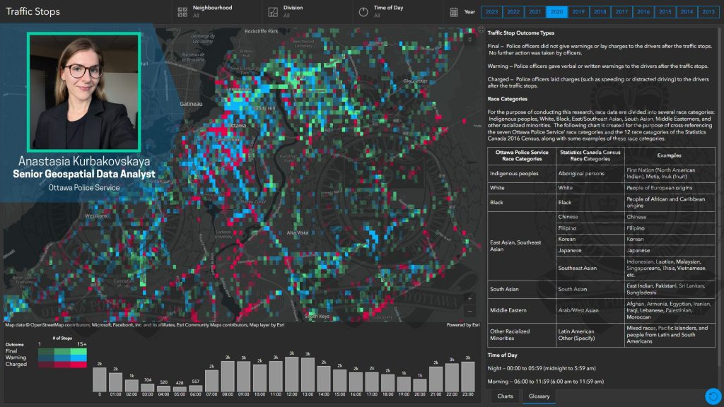
The map was created to complement the 10-year Traffic Stop Race-Based Data Collection Report. But while the report focused on statistical breakdowns, Kurbakovskaya’s map brought the data to life using the dimensions of time and space.
Kurbakovskaya said one of the biggest challenges was visualizing such a massive data set—nearly half a million traffic stops—without overwhelming the user.
“You can’t just plot dots on a map—it would just look like a cloud,” she said.
To overcome this challenge, she used a technique called binning which involves dividing the city into a grid of cells and aggregating the data within each one. She then used colour and transparency to distinguish volume and outcome.
“Three colors represented different traffic stop outcomes—charged, final, and warning—chosen with care to avoid any unintended emotional interpretations,” OPS said.
“Our goal is to empower residents,” Kurbakovskaya said. “We want people to access the same information police members have—so when a community policing officer is asked, ‘Are car thefts increasing in my neighbourhood?’ They can pull up a public dashboard and walk someone through the data in real time. Better yet, that person can also explore the data themselves.”
She said the core value of her work is transparency. The dashboards built by her team strive to tell stories, not just display numbers. In doing so, they are crafted with the utmost respect for privacy by geomasking locations, rounding times, and translating internal database field names into plain language.
“This recognition goes beyond innovation. It reflects our focus on transparency, equity, and evidence-based policing. It shows how OPS is working with partners to support community safety through geospatial technology,” Cameron Hopgood, Director of Strategy at OPS, said. “We’re encouraged to see this work recognized on a global stage.”
Finding out about the recognition was a surprise. Kurbakovskaya said she submitted the map for consideration but was never notified if it had been chosen.
“I was watching the live stream when I suddenly thought, ‘that looks really familiar’,” she said. “Then I noticed it in the bottom right corner—and realized, that’s our map!”
Beyond the international recognition, Kurbakovskaya said the most rewarding part of her work is helping community members have conversations rooted in facts. She said since its launch in 2023, the Community Safety Data Portal (CDSP)has come a long way in doing so.
“The CSDP is a home to many great maps, dashboards, and datasets that each tell a story and are each helpful for the community in its own way,” she said. “There is a lot of talent, unique skills, and fresh ideas on this team – we are just getting started.”
The OPS Community Safety Data Portal will be featured at the 2025 Esri Canada User Conference on Nov. 2 to 4 in Toronto.